The exact address of the chalet:
                      Rekreacni stredisko
                      Sprava dalkovych kabelu
                      Paseky nad Jizerou 99
                      512 47
                      Czech Republic
                      Phone 420-(0)2-7984021
                            420-(0)432-522350
The distance from Prague to Paseky is approximately 120 km to the north-east and time needed to cover that distance by car is maybe close to 2 hours since the last kilometers you drive in an almost-mountain terrain (approx 1000m high). The hills in which Paseky lies are called Krkonose.
Now, let me try to describe you how to get there.
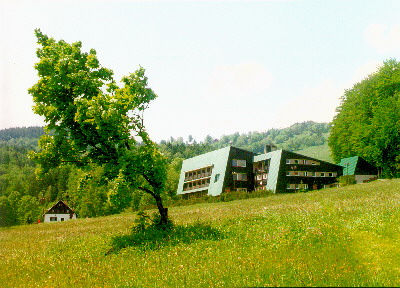
In Prague you should search for the highway to directions: Mlada Boleslav, Turnov, Harrachov, Zelezny Brod. You leave the Prague on that highway, coming through towns Mlada Boleslav, Turnov. Somewhere near the town of Turnov there is an end of the highway and you continue on a ordinary road. You go to Zelezny Brod and then to Plavy (in general, the direction should be always Harrachov, but you should go through the towns which I mentioned). The distance from Prague to Plavy is approximately 100 km. Now: in Plavy you turn right to the direction of Zlata Olesnice and then you follow the direction of Sklenarice. Sklenarice are at the distance about 10-15 km from Plavy. Then, in Sklenarice on the crossroad you turn left and after some 1.5 km you turn right, following the arrow PASEKY. (Actually, the full name is Paseky nad Jizerou, but it's often abbreviated to Paseky n. Jiz. or simply Paseky). Then, after some 2 km you should be there. The hotel is located on your right-hand side, it is a big house with a green roof. When coming near to the hotel, there is a hill on your left-hand side with ski-tow.
Anyway, I think it's worth to have a look at the map and to try to find a way on the map. In case you get lost on the map (because some of the villages I mentioned are really small ones), Paseky lies some 15 km away from Harrachov or Rokytnice, which are a bit bigger towns so that they can be on the global map of the Czech Republic. If you want, I can send you a local map of the neighborhood of Paseky, maybe it would be useful for you.
In any case, please, let me know if you come by car or if you join us in our bus (just to know if we should wait for you) and if I should send you a local map of Paseky.
 TeX form of local names:                 %      Ascii emulation:
                                          %
                                          %         v ,   v
 Rekrea\v cn\'\i{} st\v redisko           %   Rekreacn| stredisko
                                          %
                                          %      ,    ,    ,        o
 Spr\'ava d\'alkov\'ych kabel\accent23u   %   Sprava dalkovych kabelu
                                          %
                                          %       ,
 Mlad\'a Boleslav                         %   Mlada Boleslav
                                          %
                                          %   v     ,
 \v Zelezn\'y Brod                        %   Zelezny brod
                                          %
                                          %       ,    v
 Zlat\'a Ole\v snice                      %   Zlata Olesnice
                                          %
                                          %           v
 Sklena\v rice                            %   Sklenenarice
                                          %
See also a picture of the chalet (60 kB)
and maps (770 kB).